The Geometry of a Ruined Morning
Most weather apps treat fog like a flat, 2D blanket on a map. As a designer and builder, I have learned to see the atmosphere as a 3D structure with a floor, a ceiling, and real internal volume.
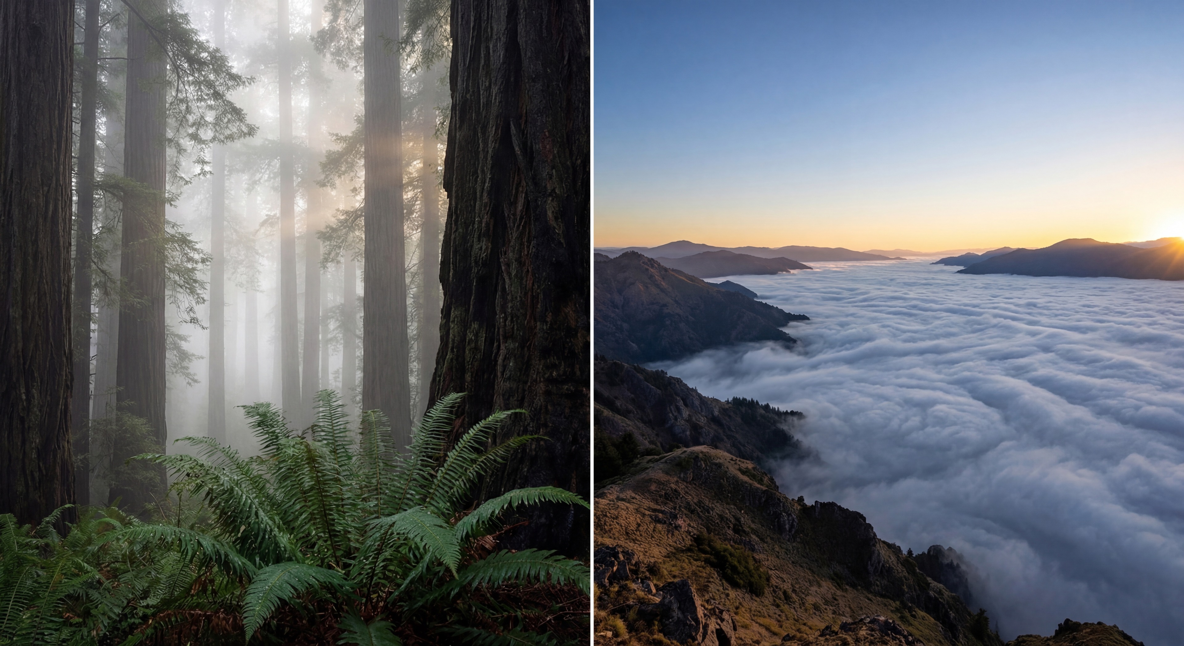
The difference between a ruined morning in a gray whiteout and a portfolio-defining sea of fog is often not the weather itself. It is your elevation relative to the fog top.
The Kerry Park Whiteout (A 300-Foot Failure)
- The signal: Back in Seattle, the NWS issued a Dense Fog Advisory. My internal logic said: dense fog equals epic photos.
- The plan: I packed my kit and drove to Kerry Park, one of the most iconic skyline viewpoints in the city.
- The reality: I arrived in the freezing dark, but when first light hit there was no skyline and no structure. Just a flat gray wall.
- The lesson: I was standing at about 200 feet of elevation. The fog was roughly 500 feet thick. I was in the soup when I wanted to be above the sea.
- The pivot: Had I gone to the Columbia Tower or the Space Needle, I likely would have looked down at a glowing deck. The shot was close. I was simply on the wrong side of the ceiling.

The question is not, "Will it be foggy?" The question is, "Do I want to be in the soup or above the fog?"


Two Intentions, Two Data Sets
Before you pack your bag, choose your workflow first. Are you hunting intimate textures, or are you chasing a grand inversion vista?
In the Soup Intimate and woodland | Above the Fog Grand and viewpoint |
|---|---|
Primary signal Fog Density | Primary signal Fog Height (Top) |
Desired light Sky Above (light leakage) | Desired light Clean horizon with minimal high cloud |
Goal Cinematic layering | Goal Sea of fog |
Light check Use Sky Above to judge if light can leak through. | Light check Use Sky Above to judge sunrise edge and deck illumination. |
Field strategy Arrive early and adapt as density shifts. | Field strategy Carry one backup location in a different elevation band. |
The Soup Density Scale
If you choose to stay in the soup, image quality is controlled by fog density.
Fog density is a surface-level read at your saved spot. It blends visibility, humidity, dew-point compression, and wind stability to answer a practical question: is this subtle mist, cinematic layering, or white-room risk?
Usually visibility above 1 mile. Good for subtle mood and cleanup, but most background clutter is still visible.
Roughly 0.25 to 0.75 miles visibility. The Goldilocks zone for woodland depth: enough opacity to simplify, enough contrast to keep subjects crisp.
Below 0.1 mile visibility. Grand scenes collapse into a gray box. Pivot to intimate, abstract, or macro compositions instead of fighting flat light.
You Found Fog. What Is the Sky Above Doing?
Finding fog is only half the battle. To estimate light quality, you need to read Sky Above: the mid- and high-level cloud cover above the fog layer.
Low cloud is excluded because it is often the fog deck itself. The real question is whether sunlight can actually reach the top of the layer.
Clear air above the fog. Expect stronger contrast and a better chance of rays as direct light enters the moisture.
Thin cloud above. Expect softer glow and wider highlight latitude, which is often ideal for forest scenes.
Thick overcast above the deck. Light stays flat and muted. Lean into minimalism, tone, and structure over color drama.
The Inversion Lid (Understanding Height)
Fog does not rise forever. It is usually capped by a temperature inversion: a stable layer where air temperature increases with height and traps moisture below.
Fog Height is derived from vertical atmospheric structure, including pressure-level humidity and inversion context, then confidence-gated before it appears in your dashboard.

The Drainage Logic
Think of valley fog like a heavy fluid. On clear nights, cold air drains off ridges and pools in lower basins. If you stand in that pool, you are swimming in the soup. To get above it, you need a read on how deep the pool is.
Viewpoint elevation is comfortably above estimated fog top.
Signal conflict or low confidence. Keep a second location in a different elevation band.
Viewpoint is at or below the estimated top. Great for immersive mood, poor for large scenic reveals.
Solving the Vertical Puzzle with Fog-Index
I did not want to guess anymore, so I designed Fog-Index around three photographer-first indicators:
- Fog Density Verdict: Thin Mist, Cinematic Layering, or White Room risk.
- Fog Height Proxy: Estimated fog-top altitude (ASL).
- Viewpoint Verdict: A confidence-gated above-the-deck or in-the-layer read at your saved location.
Instead of making a deterministic "you will see fog" claim, the product stays probabilistic and tells you whether you are likely above the deck or likely in the layer.

Summary: Run the Decision Framework
Understanding fog as a volume, not a surface, is the first step to mastering the atmospheric hunt. Track both density and height, and you move from gambling with your mornings to planning them with intent.